
پرونده:Great-neck-ny-map.gif
تفکیکپذیری بالاتری در دسترس نیست.
Great-neck-ny-map.gif (۵۷۵ × ۴۲۵ پیکسل، اندازهٔ پرونده: ۵۷ کیلوبایت، نوع MIME پرونده: image/gif)
این پرونده در ویکیانبار موجود است. محتویات صفحهٔ توصیف آن در زیر نمایش داده میشود. |
خلاصه
| توضیح |
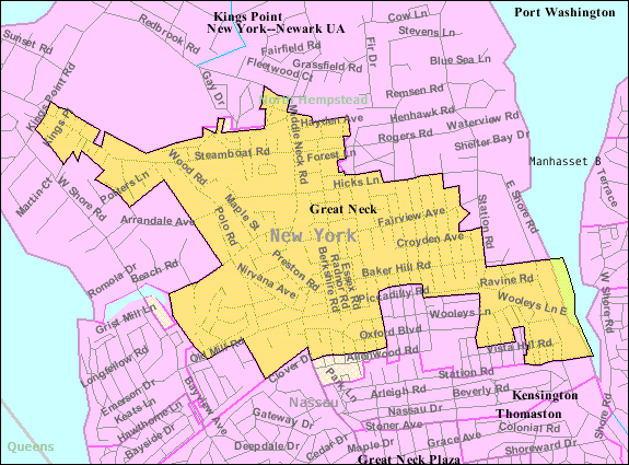
English: U.S. Census 2000 reference map for Great Neck, New York. The amber and light cross-hatched areas bordered in magenta indicate the census tracts included in the census-designated place. The amber-colored areas bordered in black indicate the extent of the incorporated Village of Great Neck. The extent of "Great Neck, New York" as the term is used by the United States Postal Service, local government and local residents includes all the incorporated and unincorporated areas of the entire Great Neck peninsula, as well as an area south of the peninsula extending to the border with Queens (New York City). |
| تاریخ | |
| منبع |
|
| پدیدآور | United States Census Bureau |
اجازهنامه
This image or file is a work of a United States Census Bureau employee, taken or made as part of that person's official duties. As a work of the U.S. federal government, the image is in the public domain.
|
 |
سیاهه بارگذاری اصلی
صفحهٔ اصلی توضیحات اینجابود. همهٔ نامهای کاربر زیر به en.wikipedia اشاره دارند.
Upload date | User | Bytes | Dimensions | Comment
- 2007-11-28 00:59 (UTC) | Americasroof | 58710 (bytes) | 575×425 | [[Great Neck, New York]] map from U.S. Census
تاریخچهٔ پرونده
روی تاریخ/زمانها کلیک کنید تا نسخهٔ مربوط به آن هنگام را ببینید.
| تاریخ/زمان | بندانگشتی | ابعاد | کاربر | توضیح | |
|---|---|---|---|---|---|
| کنونی | ۱۰ ژانویهٔ ۲۰۱۲، ساعت ۱۳:۳۳ | | ۵۷۵ در ۴۲۵ (۵۷ کیلوبایت) | SreeBot | (Original text) : Great Neck, New York map from U.S. Census |
کاربرد پرونده
صفحهٔ زیر از این تصویر استفاده میکند:
کاربرد سراسری پرونده
ویکیهای دیگر زیر از این پرونده استفاده میکنند:
- کاربرد در ca.wikipedia.org
- کاربرد در cy.wikipedia.org
- کاربرد در en.wikipedia.org
- کاربرد در eu.wikipedia.org
- کاربرد در fr.wikipedia.org
- کاربرد در ht.wikipedia.org
- کاربرد در sh.wikipedia.org
- کاربرد در sr.wikipedia.org
- کاربرد در www.wikidata.org