
پرونده:Eastern Frontier, Cape of Good Hope, ca 1835.png

پروندهٔ اصلی (۸۳۶ × ۷۳۳ پیکسل، اندازهٔ پرونده: ۲۷۹ کیلوبایت، نوع MIME پرونده: image/png)
این پرونده در ویکیانبار موجود است. محتویات صفحهٔ توصیف آن در زیر نمایش داده میشود. |
خلاصه
| توضیح |
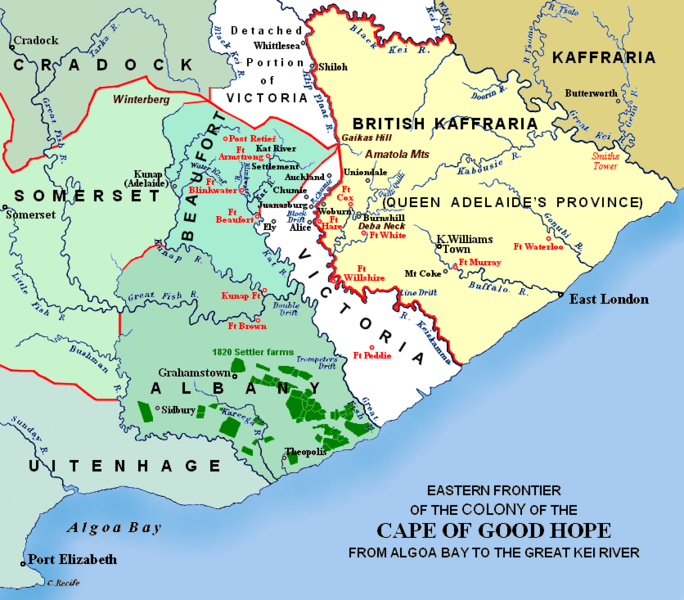
(i.e. period between 5th and 8th Xhosa Wars) 1820 British settler farms in the Albany district, or eastern Zuurveld
Settled colonial area (est. 1795), showing Grahamstown (est. 1812), and districts (est. 1820) in shades of pale green
Neutral zone (est. 1820), as agreed between Lord Charles Somerset and the Gaika (Ngqika) faction of the amaXhosa.
British Kaffraria (est. 1835), incl. East London (est. 1847): Gaika faction of amaXhosa and amaTembu under British protection.
Kaffraria, incl. Butterworth Wesleyan mission (est. 1827): amaTembu living inland and amaXhosa nearer the coast.
Mountains and necks, incl. Gaika's Hill 32°32′46″S 26°57′07″E / 32.54611°S 26.95194°E in the easternmost Winterberg.
Military forts, district boundaries and eastern frontier.
Notes
|
| تاریخ | Redrawn and coloured in December 2007 |
| منبع | Based on the source map below, last published in 1903. |
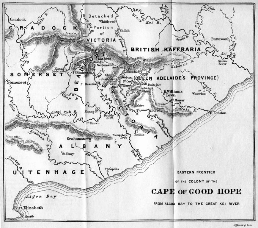
| پدیدآور | I created the map, based partly on the source map: Eastern frontier of the Colony of the Cape of Good Hope from Algoa Bay to the Great Kei river, which appears opposite page 620 of ‘The autobiography of Lieutenant-general Sir Harry Smith’ by G.C.B. Bart, Chapter xlviii, published 1903, as part of the online Build a Book initiative. JMK 11:03, 26 December 2007 (UTC) |
| دیگر نسخهها |
The original map relates to 1850 more or less, and may be John Arrowsmith's 1851 Eastern Frontier of the Colony of the Cape of Good Hope (and part of Kafirland), From Algoa Bay to the Great Kei River. Arrowsmith's lithograph was redrawn and compiled chiefly from M.S. Surveys & Sketches, communicated by Lt. Col. Mitchell late Survr. Genl. of the Colony and Captn. Wm Owen ...: _(14761876926).jpg) Compare also Arrowsmith, 1836:  |

اجازهنامه

|
اجازهٔ کپی، پخش و/یا تغییر این سند تحت شرایط مجوز مستندات آزاد گنو، نسخهٔ ۱٫۲ یا هر نسخهٔ بعدتری که توسط بنیاد نرمافزار آزاد منتشر شده؛ بدون بخشهای ناوردا (نامتغیر)، متون روی جلد، و متون پشت جلد، اعطا میشود. یک کپی از مجوز در بخشی تحت عنوان مجوز مستندات آزاد گنو ضمیمه شده است. |
- شما اجازه دارید:
- برای به اشتراک گذاشتن – برای کپی، توزیع و انتقال اثر
- تلفیق کردن – برای انطباق اثر
- تحت شرایط زیر:
- انتساب – شما باید اعتبار مربوطه را به دست آورید، پیوندی به مجوز ارائه دهید و نشان دهید که آیا تغییرات ایجاد شدهاند یا خیر. شما ممکن است این کار را به هر روش منطقی انجام دهید، اما نه به هر شیوهای که پیشنهاد میکند که مجوزدهنده از شما یا استفادهتان حمایت کند.
- انتشار مشابه – اگر این اثر را تلفیق یا تبدیل میکنید، یا بر پایه آن اثری دیگر خلق میکنید، میبایست مشارکتهای خود را تحت مجوز یکسان یا مشابه با ا اصل آن توزیع کنید.
تاریخچهٔ پرونده
روی تاریخ/زمانها کلیک کنید تا نسخهٔ مربوط به آن هنگام را ببینید.
| تاریخ/زمان | بندانگشتی | ابعاد | کاربر | توضیح | |
|---|---|---|---|---|---|
| کنونی | ۱۳ ژانویهٔ ۲۰۲۱، ساعت ۰۰:۵۷ | | ۸۳۶ در ۷۳۳ (۲۷۹ کیلوبایت) | JMK | add label |
| ۱۳ مهٔ ۲۰۱۹، ساعت ۱۱:۴۱ |  | ۸۳۶ در ۷۳۳ (۲۷۸ کیلوبایت) | JMK | Change map colour east of Great Kei River (based on comments received), as it was never part of British Caffraria. Other minor changes. | |
| ۳۰ دسامبر ۲۰۰۷، ساعت ۱۱:۴۷ |  | ۸۳۶ در ۷۳۳ (۲۵۳ کیلوبایت) | JMK | Update | |
| ۲۶ دسامبر ۲۰۰۷، ساعت ۱۰:۵۸ |  | ۸۳۶ در ۷۳۳ (۲۵۷ کیلوبایت) | JMK | {{Information |Description=Eastern frontier of the Colony of the Cape of Good Hope from Algoa Bay to the Great Kei river *Settled colonial area shown in green, with districts established in 1820 shown in different shades of green *Neutral zone agreed on b | |
| ۲۶ دسامبر ۲۰۰۷، ساعت ۱۰:۵۵ |  | ۸۳۶ در ۷۳۳ (۲۵۷ کیلوبایت) | JMK | {{Information |Description=Eastern frontier of the Colony of the Cape of Good Hope from Algoa Bay to the Great Kei river *Settled colonial area shown in green, with districts established in 1820 shown in different shades of green *Neutral zone agreed on b |
کاربرد پرونده
صفحهٔ زیر از این تصویر استفاده میکند:
کاربرد سراسری پرونده
ویکیهای دیگر زیر از این پرونده استفاده میکنند:
- کاربرد در af.wikipedia.org
- کاربرد در ca.wikipedia.org
- کاربرد در de.wikipedia.org
- کاربرد در en.wikipedia.org
- کاربرد در eo.wikipedia.org
- کاربرد در es.wikipedia.org
- کاربرد در fr.wikipedia.org
- کاربرد در he.wikipedia.org
- کاربرد در it.wikipedia.org
- کاربرد در ja.wikipedia.org
- کاربرد در mk.wikipedia.org
- کاربرد در nl.wikipedia.org
- کاربرد در ru.wikipedia.org
- کاربرد در sv.wikipedia.org
- کاربرد در uk.wikipedia.org
- کاربرد در www.wikidata.org
- کاربرد در xh.wikipedia.org