
پرونده:Karte Nordostgrönland Koch 1911.png

پروندهٔ اصلی (۱٬۱۹۶ × ۱٬۵۴۲ پیکسل، اندازهٔ پرونده: ۱٫۴۶ مگابایت، نوع MIME پرونده: image/png)
این پرونده در ویکیانبار موجود است. محتویات صفحهٔ توصیف آن در زیر نمایش داده میشود. |
خلاصه
| توضیح |
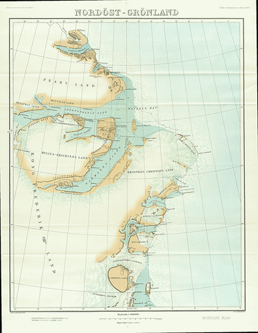
English: Map of North East Greenland by Johan Peter Koch as surveyed during the Danmark Expedition 1906-1908
Deutsch: Johan Peter Kochs Karte Nordostgrönlands, angefertigt nach der Landvermessung durch die Danmark-Expedition 1906-1908 |
| تاریخ | |
| منبع | J. P. Koch: Danmark-Ekspeditionens Kort, Geografisk Tidsskrift, 21 ,1911–1912, p. 167–177 ([1], p. 4 of 18) |
| پدیدآور | Johan Peter Koch (1870-1928) |
اجازهنامه
|
این اثر در کشورهایی و مناطقی که مدت زمان حق تکثیر، عمر پدیدآورنده بعلاوه 70 سال یا کمتر بعد از مرگ او است، در مالکیت عمومی قرار دارد.
| |
| این پرونده تحت قانون حق تکثیر محدودیت آزاد منتشر شده که شامل تمامی حقوق مربوطه و حقوق نزدیک به آن میشود. | |
تاریخچهٔ پرونده
روی تاریخ/زمانها کلیک کنید تا نسخهٔ مربوط به آن هنگام را ببینید.
| تاریخ/زمان | بندانگشتی | ابعاد | کاربر | توضیح | |
|---|---|---|---|---|---|
| کنونی | ۲۰ ژانویهٔ ۲۰۱۹، ساعت ۱۱:۲۱ | | ۱٬۱۹۶ در ۱٬۵۴۲ (۱٫۴۶ مگابایت) | Ratzer | bessere Auflösung? (Test) |
| ۳ ژوئن ۲۰۱۵، ساعت ۲۰:۲۷ |  | ۹۹۰ در ۱٬۲۹۰ (۶۷۷ کیلوبایت) | Cmdrjameson | Compressed with pngout. Reduced by 823kB (54% decrease). | |
| ۱۳ ژوئن ۲۰۱۴، ساعت ۰۹:۲۴ |  | ۹۹۰ در ۱٬۲۹۰ (۱٫۴۷ مگابایت) | Dreizung | {{Information |Description ={{en|1=Map of North East Greenland by Johan Peter Koch as surveyed during the Danmark Expedition 1906-1908}} {{de|1=Johan Peter Kochs Karte Nordostgrönlands, angefertigt nach der Landvermessung durch die Danmark-Expediti... |
کاربرد پرونده
صفحههای زیر از این تصویر استفاده میکنند:
کاربرد سراسری پرونده
ویکیهای دیگر زیر از این پرونده استفاده میکنند:
- کاربرد در da.wikipedia.org
- کاربرد در de.wikipedia.org
- کاربرد در en.wikipedia.org
- Danmark Fjord
- Hagen Fjord
- Frederick E. Hyde Fjord
- Zachariae Isstrom
- Lynn Island
- Princess Thyra Island
- Holm Land
- Ingolf Fjord
- Academy Glacier (Greenland)
- Lambert Land
- Cape Bridgman
- Mylius-Erichsen Land
- Mallemuk Mountain
- Roosevelt Range
- Daly Range
- Flade Isblink
- Amdrup Land
- Antarctic Bay (Greenland)
- Wyckoff Land
- Cape Clarence Wyckoff
- Herluf Trolle Land
- کاربرد در es.wikipedia.org
- کاربرد در fi.wikipedia.org
- کاربرد در fr.wikipedia.org
- کاربرد در it.wikipedia.org
- کاربرد در nl.wikipedia.org
- کاربرد در sv.wikipedia.org
- کاربرد در www.wikidata.org