
پرونده:Outer Hebrides UK location map.svg

حجم پیشنمایش PNG این SVG file:۴۵۶ × ۶۰۰ پیکسل کیفیتهای دیگر: ۱۸۲ × ۲۴۰ پیکسل | ۳۶۵ × ۴۸۰ پیکسل | ۵۸۴ × ۷۶۸ پیکسل | ۷۷۹ × ۱٬۰۲۴ پیکسل | ۱٬۵۵۷ × ۲٬۰۴۸ پیکسل | ۱٬۰۸۳ × ۱٬۴۲۴ پیکسل.
پروندهٔ اصلی (پروندهٔ اسویجی، با ابعاد ۱٬۰۸۳ × ۱٬۴۲۴ پیکسل، اندازهٔ پرونده: ۳٫۲۵ مگابایت)
این پرونده در ویکیانبار موجود است. محتویات صفحهٔ توصیف آن در زیر نمایش داده میشود. |
| توضیح |
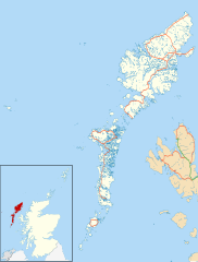
Blank map of the Outer Hebrides (excluding Sula Sgeir), UK with the following information shown:
Equirectangular map projection on WGS 84 datum, with N/S stretched 180% Geographic limits:
|
| تاریخ | |
| منبع |
|
| پدیدآور | Nilfanion, created using Ordnance Survey data |
| اجازهنامه (استفادهٔ مجدد از این پرونده) |
این پرونده با اجازهنامهٔ کریتیو کامانز Attribution-Share Alike 3.0 سازگار نشده منتشر شده است. انتساب: Contains Ordnance Survey data © Crown copyright and database right
|
| دیگر نسخهها | File:Outer Hebrides UK blank map.svg - Blank map |
تاریخچهٔ پرونده
روی تاریخ/زمانها کلیک کنید تا نسخهٔ مربوط به آن هنگام را ببینید.
| تاریخ/زمان | بندانگشتی | ابعاد | کاربر | توضیح | |
|---|---|---|---|---|---|
| کنونی | ۲۶ سپتامبر ۲۰۱۰، ساعت ۲۰:۲۳ | | ۱٬۰۸۳ در ۱٬۴۲۴ (۳٫۲۵ مگابایت) | Nilfanion | {{Information |Description=Blank map of the Outer Hebrides (excluding Sula Sgeir), UK with the following information shown: *Administrative borders *Coastline, lakes and rivers *Roads and railways *Urban areas Equire |
کاربرد پرونده
صفحههای زیر از این تصویر استفاده میکنند:
کاربرد سراسری پرونده
ویکیهای دیگر زیر از این پرونده استفاده میکنند:
- کاربرد در ar.wikipedia.org
- کاربرد در bg.wikipedia.org
- کاربرد در ceb.wikipedia.org
- کاربرد در de.wikipedia.org
- کاربرد در en.wikipedia.org
- Outer Hebrides
- Stornoway Airport
- Lochboisdale
- Daliburgh
- Callanish
- Stornoway
- Kisimul Castle
- Uig, Lewis
- Rodel
- RRH Benbecula
- Leverburgh
- Castlebay
- Balivanich
- Cladh Hallan
- Back, Lewis
- Knock, Isle of Lewis
- Ardmore, Barra
- Ness, Lewis
- Barra Airport
- Portnaguran
- Aignish
- Dun Carloway
- Shawbost
- Gravir
- Barvas
- Garenin
- Achmore, Lewis
- Aird, Lewis
- Ardhasaig
- Balallan
- Bragar
- Lochmaddy
- Hushinish
- Carloway
- Tarbert, Harris
- Benbecula Airport
- Northbay
- Sollas
- Howmore
نمایش استفادههای سراسری از این پرونده.